Reinhard Mueller, Petro Braverman, Mirko Thiel
A Traffic Separation Scheme (T.S.S.) is a virtual object displayed in a nautical chart to enhance the safety of vessel traffic by orientation depending separation of traffic flow. In advance of the passage the ship master by himself has to make sure about the T.S.S. to navigate in a safe manner conform with the mandatory recommended rule 10 of COLREGs (Convention on the International Regulations for Preventing Collisions at Sea). Generally, the common risk potential increases by the human factor in high vessel traffic density situations. Assistance from an overlooking outside party cannot be expected as only fewest T.S.S. are observed by shore-based Vessel Traffic Service Centres (VTS).
The following paper describes a method which shows the possibility of monitoring and evaluating the vessel traffic in and around[ds_preview] a T.S.S. automatically. The solving approach is based on the investigation of AIS signals (Automatic Information System) in the vicinity of any given T.S.S. The paper also discusses the results of a realized case study executed in the Baltic Sea.
Many a visitor to the British capital may have learned painfully that the behavior pattern of the road traffic is different from the pattern on the footpath. Especially rigorous collisions are possible in the narrow subways of the Underground during rush hours. A single wrong left side passage spreads out into a string of walk irritations like a domino effect. The person walking on the wrong side will induce different obstacle avoidance manoeuvers of others coming towards him. The manoeuvers’ degree of effectiveness and quality depends both on the space available and the movement ability. Markings and labels giving direction recommendations plus separation are valuable and helpful means to assist traffic flow optimization – but sometimes they are overlooked by individual footpath users. The same scene can happen in road traffic due to the passive highway traffic signaling system. Now and then the proper slipway will be ignored by a motor driver.
It would be irresponsible though to guess that this kind of human factor would not apply in vessel traffic and that everything runs perfect within of a Traffic Separation Scheme.
Mostly, the nautical engineer sees a T.S.S. as a virtual object marked in a sea chart which is physically just about visible through binoculars if the traffic running ahead is already ranged. T.S.S. approaching and passing procedures are solely in the ship master’s responsibility. Hazard caution exercised by a third party is not available if the sea area is not protected by observation centers like VTS. Active alerting, however, makes sense as is shown by sickle-shaped wheel clamps installed across slipways. If the lane is used in the given direction the vehicle’s tires push the rounded side of the clamp into the road surface. If not, the tires roll into the clamps’ pikes which destroy them, thus avoiding the hazard potential. A dramatic scene like that is of course unthinkable in the maritime domain. However, there are possibilities of an autonomous and technology-driven assistance for hazard caution in cases of rule violation. The necessary technical infrastructure should be discussed.
In the following a method for a self-controlled monitoring of vessel traffic inside and around the traffic separation scheme (T.S.S.) will be introduced. AIS-based traffic monitoring assesses the compliance of rule 10 of COLREGs (Convention on the International Regulations for Preventing Collisions at Sea) and detects any violation and its origin. This application runs autonomously and may be implemented ashore, at sea and in the orbit as well. The method aims at further enhancing sea traffic safety.
Introducing the T.S.S. »North of Ruegen«
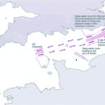
The number of daily vessel passages through the Baltic Sea is 2000 at average. Formal sources guess a further growth of transport volume and traffic flow [3]. Initialized by the countries bordering on the Baltic Sea several traffic regulation measures were established in the Baltic by the IMO for enhancing the safety and efficiency of sea traffic flow. In 2006, the T.S.S. »North of Ruegen« was installed in the neighbouring triangle between Denmark, Sweden and Germany in order to regulate the east-going and west-going transit traffic, respectively, solely by virtual markings in sea charts. The T.S.S. ranges 5 NM and consists of two one-way lanes split by a separation zone of 1 NM width. The traffic situation around the area of the T.S.S. »North of Ruegen« was analysed and evaluated by medium-term and short-term investigations based on AIS reports [6]. Already on the day after the
T.S.S. was established more than 95 % of all counted vessel passages were using the brand new traffic regulation conform to the COLREGs rule, this is a high acceptance. Among the passing vessels thirty violating ship masters were detected who steered their vessels in the wrong direction lane of the T.S.S. Further investigations have shown a number of rule 10 violations during crossing and merging of traffic lanes, respectively (6.7 % of all identified violations) [8]. In some cases up to seven vessels were involved in the same conflict. Each of them has to make obstacle avoiding manoeuvres. From the statistical point of view every hundredth vessel passes the T.S.S. with a high conflict potential. The question is how to face this uncertainness effectively?
Introducing the self-controlled monitoring of rule 10
Rule 10 of COLREGs describes the mandatory recommendation of good seamanship inside and in the vicinity of any T.S.S. defined as follows:
• Clause B, count i: A vessel using a traffic separation scheme shall proceed in the appropriate traffic lane in the general direction of traffic flow for that lane.
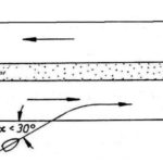
• Clause B, count iii: Normally join or leave a traffic lane at the termination of the lane, but when joining or leaving from either side a vessel shall do so at as small an angle to the general direction of traffic flow as practicable.
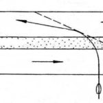
• Clause C: A vessel shall so far as practicable avoid crossing traffic lanes, but if obliged to do so shall cross on a heading as nearly as practicable at right angles to the general direction of traffic flow.
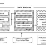
The automatic detection and identification of rule violations is based on the evaluation of AIS reports hosted by an accordant technical unit via interface (see Fig. 3). The data processed by the application are ship’s identification number, ship’s position and movement, ship’s heading and changes over the time, ship’s course and changes over a period of time. For each vessel passing the T.S.S. a track will be built up, monitored and predicted to analyse the current and future traffic situation and compliance of rule 10. In case of a violation further investigations are carried out by the algorithm as identification of the origin and the involved vessels. In a post-processing procedure the identified vessel may be addressed via accordant technical unit like AIS (Binary Messages) or VHF.
A case study in a Baltic Sea test bed
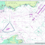
The test bed is designed by the T.S.S. »North of Ruegen« and the research platform FINO 2 [2] north of the T.S.S. in a range of 6 NM (see Fig. 4). The geographical coordinates of the T.S.S. are stored in an external knowledge base. In addition, the scheme encloses a virtual buffer zone of 0.5 NM.
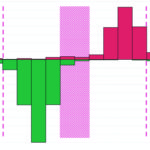
The AIS reports were received by a Base Station installed at the platform. The data of one month in autumn of 2007 were recorded and transmitted to the land-based analysis centre (see Fig. 5). It has to be mentioned that the T.S.S. is not monitored by a VTS; the local transit traffic is out of the formal assistance range.
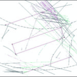
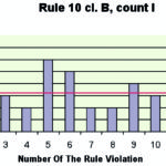
The T.S.S. self-controlling unit kept its process reliable and robust. 1217 tracks were built up by AIS reports and investigated according to the recent traffic situation. Most rule violations were caused by disregarding the recommended angles for lane crossing or merging (see Fig. 6). There were 70 cases with an average of four vessels being involved. Each conflict – that means at least two vessels with a critical distance of less than 0.5 NM – lasted about 17 minutes. Another 12 rule violations were caused by using the one-way lane in the wrong direction (see Fig. 7). In these cases an average of three vessels were involved. The maximum number vessels involved in these conflict was identified with seven targets. That particular conflict lasted 54 minutes.
Discussion of results
There is no doubt that traffic safety will be enhanced by establishing an appropriate regulation measure in cases of a restricted freedom of the seas. The maritime traffic flow will be separated and adjusted depending on orientation. Traffic lanes spreading rather wide may be reduced to an acceptable ordered transit lane width. However, the bundled sea traffic results in decreased recommended navigational space and thus in an increased traffic concentration. The potential of a local vessel bunch is increasing as well. The build-up and break-up of target clusters in time and space depends on the
• available navigational space (as T.S.S., natural depth, offshore installation)
• traffic density / frequency
• homogeneity / heterogeneity of the traffic structure.
The more the bunched targets are equal in velocity, the better the bunch keeps moving on. If target velocities differ considerably more overtaking situation can be counted [7]. Per se a target bunch is not dangerous, but the hazard potential is caused especially in a case of insecurity / damage of a target inside or on the periphery of the formation. Several targets are then involved in the conflict and have to act at once.
The monitoring of vessel traffic is realized by a well-established transponder technology. AIS signals may be received and transmitted in coastal areas by base stations and in offshore range areas by repeater stations. This infrastructure operates as a bi-directional communication link. The information exchange is possible ship to ship, ship to shore, shore to ship and shore to shore. In general, the introduced method of automatic traffic monitoring may operate at any AIS-covered location – shore-based, on board of a ship, on top of a buoy, integrated in orbit. In case of a ship-based installation this method is comparable with the ARPA function of the radar. Both methods analyse target movements by tracking, one by analogue (but autarchic) target signals, the other by digital (but identified) ones. The necessity of quality and integrity of position data is still urgent.
The family of identification and tracking technologies is growing constantly.
The distant vessel traffic in open sea areas may also be covered and monitored by the system installation of the Long Range Identification and Tracking (LRIT) [4]. North Earth or other opertors (e.g. Iridium, Orbcom) offer worldwide services of transponder tracking with full availability [1]. However, without an additional technical device provided by the carrier only a one-way communication link is given.
A return link allows increased possibilities of communication like an addressed information exchange. In the context of the introduced method this means that in case of a detected violation all targets involved in the conflict may automatically receive an alert message by the transmitting automatic monitoring unit. This idea of technology is already introduced in [5]. Similar to the medical technology of the minimal invasive surgery the ship master will be addressed routinely by an electronic unit if a particular incident is detected. The hazard potential may be removed or reduced by a minimum of steering intervention of velocity and course order. The transmission of appropriate messages via AIS Binary Messages is also possible.
Extending the established vessel traffic measures by an electronic intelligence offers the possibility of enhancing traffic safety, of foresighted steering conformance and of exercising strictest self-discipline in rule compliance.
Prof. Reinhard Mueller, Petro Braverman, Mirko Thiel


