Rising bunker costs and strict environmental targets are constraining voyage planning. By estimating optimal speed and route profiles based on empirical data and statistical models savings up to 10 % can be achieved, writes Eniram expert Jussi Pyörre
Getting into port on schedule – on time, but not too early – is a difficult science to get right when vessels[ds_preview] can encounter any number of variables along their voyage. Until now, operators have got round this by building buffers into their journeys, giving them time to play for if sea conditions threaten to throw their schedules off course. The practice is far from efficient however, not least because of the fuel implications of varying speeds during a long passage.
Volatile bunker prices and strict environmental targets are driving technology solutions to address the constraints of voyage planning by estimating journey times and speed requirements. In almost all cases however, such calculations are made based on theoretical information rather than real-time data. This limits the extent to which a ship’s operator and crew can be truly confident in the estimates.
Until now, that is. Eniram has invested in software development that enables operators to capture, analyze and exploit real-time data, adjusting performance dynamically based on the latest readings. Known as the Optimum Speed Assistant (OSA), this tool gives operators greater control, reducing the need for a buffer and enabling vessels to confidently maintain a consistent speed throughout a voyage. Speed optimization of a vessel’s voyage is the key to achieving this control. This article takes a closer look at what we mean by speed optimization, the challenges surrounding it and offers a considered approach to overcoming the obstacles to achieving it.
Speed optimization schemes face tough challenges in daily vessel operations due to strict itinerary demands and the limited accuracy of available weather and sea current forecasts. Since fuel-optimal routing is highly sensitive to constraints such as just-in-time arrival, one high-speed leg can wipe out the accumulated fuel savings of an entire voyage.
In this article, we consider an approach to optimal speed estimation which is based on statistical route forecasts derived from historical data measured on specific routes. The optimization scheme includes penalties for the undesired consequences of certain operating actions, such as excessive acceleration, as well as rewards for taking correct measures, such as maintaining a consistent speed, as appropriate. We conducted simulation scenarios to provide alternative and improved energy efficient speed profiles. Our study is based on analyzing available operational data collected from twenty vessels. We used this data and our extensive nautical experience to model the environmental effects on optimal speed profile. We found that in taking care to optimize speed can achieve possible 3 ± 1 % energy savings.
1. Challenges
The challenge of route and speed optimization is often characterized by strict time constraints and noisy signals. Recent developments in measurement systems mean it is now possible to measure many parameters on board a vessel and over lengthy voyages. But it is only by analyzing this data in detail that a clear picture into the vessel’s behavior can be gained. Many brilliant minds and earlier studies have helped to pinpoint the various challenges in route optimization including the following notable ones:
• Quality of data: This is especially an issue in vessel energy consumption estimation. Quality issues include data correctness (validity), consistency, resolution, and completeness (sufficiency).
• Difficulty in accurately estimating time of arrival: This is often subject to change and dependent on prevailing environmental conditions. Waves and weather impact the speed the vessel is able to travel.
• Off-design conditions for the vessel or propeller: Care should be taken to optimize propeller use to avoid excess fuel consumption. For example, excessive acceleration can be avoided by reducing RPM variation.
• Weather forecasting limitations: Since this is still largely based on probability rather than accuracy, the reliability of any forecast needs to be included in the evaluation of the optimization results.
• Service speed estimations: It is difficult to estimate the service speed obtainable by a vessel in real weather conditions when sailing on a given shipping route, or indeed to support routing decisions in heavy seas.
• Operating profile of the engine: These profiles are complex and are impacted by changing engine operational characteristics due to partial loading conditions or technical degradation of the engine.
• Hydrodynamics: Use of hydrodynamic modeling while in operation is impractical and the approach of applying multidisciplinary design optimization is weakly developed in the marine context.
• Timely intervention: Operators often have differing opinions on vessel operations and optimum settings based on their own experience. This means detecting small changes in the sea conditions is difficult to capture. On larger vessels, the control settings of variable parameters are typically adjusted on an hourly basis rather than within minutes. A key challenge is to assist the operator in keeping the adjustments that impact energy consumption to a minimum while taking account of changes in the condition of the vessel and its environment at appropriate intervals.
• User acceptance: For a system providing operational assistance it is crucial to gain acceptance from the operator. This involves attaining some degree of confidence in using the man-machine-interface that informs and drives operational decision making. It depends particularly on ease-of-use, usefulness, and on adequate support provided to onboard decision makers.
At Eniram, we have carefully considered an approach to speed optimization that seeks to address these highlighted challenges. Our main approach is based on empirical data and statistical models using this data to devise new optimization scheme. This scheme emphasizes ease-of-use and develops a model that can provide accurate prediction for the estimated time of arrival (ETA), and optimization to meet just-in-time arrival needs. We emphasize transparent use of reliable and accurate sea current and weather forecasts that supports onboard decision making. Additionally, we include results from a preliminary study we undertook to estimate potential savings achieved using speed profile optimization.
2. Data for speed optimization
There is variety of data measurements impacting vessel performance that is useful in determining speed optimization. Information with influence includes the changing variables relating to the condition of the vessel such as its maintenance (e. g. hull dimensions, coating and cleaning data) and historical operational data measurements (e. g. high frequency time series of engine load). In order to measure hull motion accurately, additional sensors such as inclinometers and radars can be mounted onboard the vessel to monitor draft dynamically. Finally, accurate and reliable forecasts of sea and wind condition accompanied with tidal and sea current modelling also support fuel efficient operational profile and route planning.
2.1. Historical data
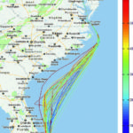
Access to historical data is essential when determining forecasts and optimizing the accuracy of route and speed profile planning algorithms. Data measuring the vessels operating conditions and onboard variables combined with historical port-specific itinerary variations are prerequisites in determining optimization for that vessel. The historical data includes the following variables: propulsion power, RPM, location (Fig. 1), speed, acceleration, attitude, draft, sea-depth, use of stabilizers and wind. If not available, sea current can be estimated using speed over ground and other variables.
Motion modeling is based on attitude sensors positioned in appropriate areas on the vessel. In a typical vessel, several inclinometers are mounted to provide data in transverse and longitudinal direction. When they are mounted fore and aft of the vessel these sensors can also provide hull deflection estimates in addition to rolling and pitching measurement. Radar data can accompany inclinometer measurements making it possible to take into account the actual wave patterns around the vessel.
Our approach to optimization has three major goals: to fully use existing data; to gain insight into real life optimization constraints during operation in actual sea conditions; and to increase reliability of route optimization. This data can be used to form baselines and reference levels. In addition, the data of actual operational profile is used in simulations to evaluate alternative profiles.
2.2. Sea current forecasts
Successful speed optimization relies heavily on accurate forecasts. Generally speaking, forecasts made on a global scale and provided by international centers do not take into account all of the specific characteristics of the local areas. This is also true of global sea current models when predicting conditions in coastal environments.
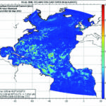
One increasingly attractive approach in dealing with this type of flaw in forecasting data is to use open data to construct current fields along the route. Fig. 2 gives an example of 144 hour surface current forecasts provided by the US Government National Oceanic and Atmospheric Administration (NOAA).
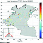
As with all environmental data, appropriate quality procedures have to be implemented so that the sea current model and forecast can be verified as well as any uncertainties of the computations quantified. The example in Fig. 2 validates NOAA forecasts against in-situ measurements. The model validation is thus done against other models, satellite data, automatic weather station and measurements by vessel operating in the sea area.
Another example of available current forecasting services is given in Fig. 1. The example shows Gulf Stream forecast based on synthesis of long-term observations and models. The commercial service is based on separate tidal and sea current modeling as well as benchmarking against best available measurements.
Finally, the level of accuracy of the forecast products must be used as fully as possible in speed optimization schemes.
3. Speed optimization formula
In our observation, keeping to the scheduled arrival time, navigating restricted speed areas and shallow waters as well as other seafaring conditions have a direct impact on speed optimization. These affecting factors should be collected into baselines and used to provide unbiased performance estimation and benchmarking. We also advocate modeling the different operational and environmental effects separately.
Speed optimization helps to solve numerically the speed distribution during the voyage in a way that minimizes the amount of fuel consumed. In addition to avoiding excessive speed, the fuel consumption of the vessel can be reduced by continually monitoring any changes in engine load and weather conditions and making the necessary engine load adjustments as changes are detected. This is why accurate information about the state of the vessel and its environmental surroundings are important in maintaining an efficient operation.
Since engine load is expressed in terms of power, engine RPM and torque are the key variables used to monitor fuel consumption. Fig. 3 shows an example of measured fuel consumption. This data can be used to build empirical engine models suitable for speed optimization. Additional factors such as density and caloric value of the fuel may be used to obtain more accurate modeling.
Eniram’s approach to optimizing vessel consumption uses statistical models based on measured operational and hydrodynamic models. The data is collected for extended periods during the operation so the statistical model can be updated to reflect cumulated data or any improved accuracy, as a result of possible upgrades such as hull coatings and retro-fits.
In practice the possibility to create specific empirical model depends on availability of accurate data. Fortunately, in many cases it is sufficient to model only the most significant components affecting the fuel consumption.
4. Implementation
The Eniram system for optimizing the operations of the vessel relies on receiving signals from the onboard automation system and sensors and applies historical data, baselines and regression models. Simulation of optimal settings for the operational parameters is performed using a multi-disciplinary design analysis and optimization framework which enables complex modeling of various disciplines, with design variables, objective function and constraints.
The defined baselines we use serve as a basis for measuring vessel performance and offer frameworks for operational comparison such as calculations of leg, voyage or specific sea area benchmarks at individual vessel level or at fleet level.
Historical measurement mapped into the baseline vector doesn’t just indicate what variables are constrained or impossible (e. g. maximum speed or trim), but also provide information on the actual preferred combination of control variables (e. g. service speed in specific sea area in specific weather conditions).
When a baseline is shown transparently to the operator, a clear understanding of typical route profile can be achieved. While baseline can be seen as a collection of static and historically averaged leg specific data, actual optimization is done interactively just before and during the voyage. Thus real-time data complements the baseline and enables dynamic optimization. For example, recommended speed is adjusted according to the changing location at sea to guarantee arrival in time. Use of historical measurements to define baselines relates to a long tradition of collecting data from shipping routes. Abundant data exists listing statistical long-term parameters of winds and waves on shipping routes. Wave size characterization might be contained in a typical atlas in a specific sea area and for a given season.
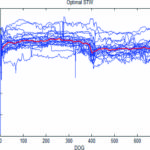
Fig. 4 presents a case where historical operational data for a specific route is used as a prerequisite condition for determining optimal speed profile.
5. Conclusions
Fuel prices compounded by environmental targets are forcing fleet operators to think harder about how they calculate and manage speed. While aiming for just-in-time arrivals into port is one way of increasing efficiency, if speed management isn’t fine-tuned as part of this strategy any financial gains could be wiped out. The additional fuel required to support variances in speed is significant enough to undermine even the best thought-out voyage optimization plans.
To maximize fuel efficiency in today’s climate, operators need to be able to maintain a more constant performance – whatever the prevailing conditions – by making appropriate adjustments using a combination of real-time readings and historical information about the known performance of a vessel in a variety of conditions.
Having confirmed with our customers that there is a real market need we wanted to come up with a solution, based on our existing data collection technology and analytical skills that would help to improve fuel efficiency using speed optimization.
Our initial study, based on operational data from twenty vessels modeling the environmental effect and simulation of optimal speed profiles, suggests possible energy savings of 3 ± 1 %. This estimate is in accordance with values of 1–5 % which have been reported elsewhere. We have found that in many cases, if a vessel has operated with significant time margins to ensure arrival in time or due to ETA, savings up to 10 % can be achieved.
We have presented an approach for estimating optimal speed and route profiles based on historical data measured on a specific route. The approach, compensating varying depth, sea currents and weather conditions, has been born out of need to provide ease-of-use guidance to vessel operators in transparent way while minimizing the probability for error in optimal speed profile.
Our optimization scheme addresses many of the challenges expressed earlier. We have introduced a scheme that is based on:
• use of high frequency operational data,
• definition of baselines,
• simulation of ETA and use of just-in-time constraint,
• regression modeling (a squat modeling as an example),
• implementation using multidisciplinary optimization,
• reliable forecasts for currents and weather and verification modeling performance using actual data.
The advantage of this data intensive approach is that accumulated leg data can be used by the crew and fleet operators to capture detailed factors to enable efficient operating.
Vessel performance management and voyage optimization is being increasingly made easier and more accurate with the help of technology. Collecting, interpreting and using both real-time and historic data is important in getting the most out of any system. For this reason, operators and their crews need to become more ready to embrace solutions and data analytics tools available. While it requires something of a real leap to let technology decide a vessel’s best speed, the potential for thousands of dollars in bunker savings on each individual voyage should be a strong incentive.
Our speed optimization decision support tool (OSA) delivers the necessary guidance and decision support to a ship’s crew to help maintain the most consistent and fuel-efficient speed, for the given route, conditions and port arrival needs.
Author:
Jussi Pyörre Vice President Technology Eniram Ltd., Helsinki/Finland info@eniram.fi
Jussi Pyörre


